New 11-hr Met Eireann warning for 3 counties amid snowfall in DAYS forecast & exact areas pinpointed in ‘shock’ switch
MET Eireann has issued a wind warning for three counties as Ireland braces for snowfall and sleet in a “shock” weather switch.
Thousands of people in Donegal, Galway and Mayo will be under the Status Yellow Wind warning later today, with the alert lasting until the early hours of tomorrow morning.

Met Eireann said there will be “strong and gusty” south-westerly winds, especially in coastal areas, that will cause difficult travelling conditions, debris and loose objects to displace and some fallen branches or trees.
The warning will be in place from 6pm this evening until 5am tomorrow morning.
Met Eireann has pinpointed when the snow will fall and a weather expert added that the white stuff will even cover lower areas.
Cathal Nolan of Ireland’s Weather Channel said that a cold front moving in from the northwest will bring the snow.
He said: “That is going to dictate our weather on Thursday. Heavy rain, strong winds in the south and into the Midlands, followed by some risky conditions on Thursday night.
“That comes in the form of sleet and snow showers and snow accumulating even down to lower levels.”
Nolan added: “We are advising people to be aware of the risk of some snow on Thursday night and indeed into Friday morning, leading to the risk of some disruption on the roads.
“And of course, this will come as quite a bit of a shock after the rather pleasant, spring-like conditions that we’ve enjoyed last week.”
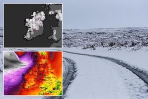
Weather maps show that the snow will fall across the west coast, the midlands and the north.
Met Eireann confirmed the snow forecast, saying that the mercury will plummet on Thursday night to between 0C and 4C.
Showers moving in from the west will fall as sleet and snow in some places, the weather experts said, and frost and ice will form overnight.
Met Eireann forecaster Ailis Hankinson added that we could see more snow on Friday night.
She said: “Turning wet and windy then on Wednesday night into Thursday with outbreaks of rain, turning heavy at times alongside fresh to strong and gusty southwest winds.
“Cooler then but staying blustery on Friday with sunny spells and scattered showers, falling as sleet and possibly snow at times in highs of just 5C and 8C.”
Today’s weather will be unsettled with an area of low pressure bringing rain and wind.
Hankinson said: “[It will be] generally cloudy with outbreaks of rain and drizzle, becoming patchier for a time this morning and early afternoon before more persistent rain extends from the west.
“Becoming breezy too with moderate to fresh south or southwest winds developing and highs of 9C and 13C.”
Tomorrow will be the most pleasant day of the week with dry and bright weather and even some spells of sunshine.
However, the Atlantic coast will see some scattered showers and a few isolated showers will extend into the east of Ireland.
And looking ahead to the weekend, Met Eireann said the weather will be “duller and milder” after the snow on Thursday and Friday.
Cloud and rain will spread across the country with highs of between 8C and 11C.
Current indications suggest that Sunday will be a “cool day” with blustery showers, Met Eireann added.